Fall is in the air. Snow is dusting some of Colorado’s peaks. And the crisp Rocky Mountain mornings and evenings mean it’s time for fall colors in Colorado when the aspen trees across the state turn bright yellow and orange.
Some people call the trees “quaking aspens” because the leaves rustle and shimmer in the wind. Related: September is prime time for aspens, so don’t miss your chance to see slopes painted in gold. Hiking and cycling are great ways to see fall colors in Colorado. You can also ride a horse through a forest full of white bark and yellow leaves. Or you can see aspens from your car window. The canyon, about 20 minutes northwest of Fort Collins, is a great place to enjoy the fall colors in Colorado, whether by car or foot. Heading up the Poudre Canyon (pronounced pooh-der), you can take Colorado Highway 14 west from U.S. Route 287. Within the first quarter mile, you’ll begin to see the Poudre River, Colorado’s only nationally designated Wild & Scenic river. The highway also is designated as a Colorado Scenic and Historic Byway. Along with many aspens, the road is also lined with beautiful ponderosa and lodgepole pine trees, sagebrush and mountain mahogany. You can take the two-hour drive, climbing above 10,000 feet, to Cameron Pass and enjoy the colors along the river from your car the entire way. Take it about 40 minutes farther for even more colors and arrive in Walden, Colorado. Or stop at one of the many trailheads on this route to see the fall colors by foot or by bike. Along the way, you will notice the remnants of the High Park Fire, which burned more than 87,000 acres in 2012, mostly on the south side of the highway lower in the canyon. Devastation from the Cameron Peak Fire, which burned in 2020 and is the state’s largest wildfire on record, also damaged areas further up the canyon, along the river and beyond, but the drive is still worth it to see fall colors. A short, mile-long hike with the kids, the stroller, or even your kayak or fishing pole takes you to this beautiful area. It follows a creek lined with changing colors and finishes at Seaman Reservoir. Gateway has picnic area and natural playground, making it a great spot to spend the day. There is a City of Fort Collins use fee. This is an easy 5-mile hike (one way) through meadows lined with aspen. It’s located off Pingree Park Road (County Road 63E) about an hour up the canyon on the left (Just past Jacks Gulch Campground). Pingree Park Road is dirt and can get slick when wet. This is a 6.5 miles (one way) moderate hike that starts in the Poudre Canyon. The trail enters the Comanche Peak Wilderness about a half mile from the trailhead and there is camping along the next seven miles. It has heavy use, but is lined with amazing fall colors. Head up Highway 14 just past The Mishawaka, a legendary music venue, restaurant and bar, and take a left onto Stove Prairie Road. At the intersection of Stove Prairie Elementary School, take a left onto Rist Canyon Road. This loop will take you back east to the small towns of Bellvue and Laporte, just outside Fort Collins. Find more details of the trails on the Poudre Wilderness Volunteers website. If you plan ahead and can score a reservation to visit Rocky Mountain National Park’s busy Bear Lake corridor, you can enjoy a beautiful fall hike in Colorado’s most visited national park. (Learn all about the timed entry reservation system in Rocky Mountain National Park, and book your reservations through Recreation.gov.) Try a relatively easy loop hike by starting at Bear Lake, hiking 1.3 miles to Bierstadt Lake, then hiking 1.5 miles down the side of a moraine, a steep hill carved long ago by glaciers. As you hike down switchbacks, you’ll see sweeping views of yellow aspens across the valley. Take the Bear Lake Shuttle Bus. You’ll start at Bear Lake and will finish at the Bierstadt Lake Trailhead. Get bus information and a hiking map. Rocky Mountain National Park offers trail rides. The YMCA of the Rockies also offers horseback riding at both the Estes Park Center on the east side of Rocky Mountain National Park and near Granby at Snow Mountain Ranch. This stunning 55-mile drive is Colorado’s oldest Scenic and Historic Byway and showcases beautiful aspen trees. The byway includes Colorado Highway 7 on the north and connects with Colorado Highways 72 and 119. The 22-mile drive leads from Victorian towns, Georgetown and Silver Plume, up to timberline on the flanks of famous 14-ers, Mount Bierstadt and Mt. Evans. This drive is also another one of the Colorado Scenic and Historic Byways. Easy. Great views of aspens with Pikes Peak in the background. This trail is a 2.6-mile round-trip hike with just 284 feet of elevation gain. Dogs are allowed on leash. To get there, take U.S. Highway 24 west from Colorado Springs 17 miles to Woodland Park. Turn right onto Baldwin Street. Go three miles to Loy Creek Road. Turn right and go 1.5 miles to Rampart Road. Turn right. Go 2.3 miles and you’ll see the parking lot on your left. Moderate. Great for families. The trail leads to pinnacle rock formations known as the Crags. From Colorado Springs, take U.S. Highway 24 west through Woodland Park to Divide. Turn south on Colorado Highway 67. Drive 4 miles. Turn left on Forest Service Road #383. The trailhead is nearly 3 miles up the road, approximately 1/8 mile before the Crags Campground. Foot, horse, and cross-country ski trail. One-way distance: 2.1 miles. Elevation gain: 800 feet. Moderate. This 5.4-mile loop weaves in and out of aspen groves and meadows on the north side of the park. Get the trail map. Mueller State Park also features cabins and campsites, and there are evening walks in the fall to hear elk bugling. To get there from Colorado Springs, take U.S. Highway 24 west to Divide. Turn left on Colorado Highway 67 and go south 3.5 miles. On this drive, you’ll get a double dose of gold: beautiful aspens and a glimpse of historic mining towns that sprang up during Colorado gold rush days back in the 1890s. This 131-mile, 5-hour drive is another one of Colorado’s Historic and Scenic Byways. Start in Florissant and head south into the Florissant Fossil Beds National Monument. From there, you’ll head to the old mining towns of Cripple Creek and Victor. Look for beautiful views of aspens on the flanks of Pikes Peak near Victor. South of Victor, the roads get rougher and won’t accommodate trailers or RVs. But, with four-wheel drive, a section known as the Shelf Road is an exciting stretch, cut into a canyon, 200 feet above the stream bed below. For a shorter drive, head west on U.S. Highway 24 from Colorado Springs, then take Colorado Highway 67 through Divide to Cripple Creek. You’ll find spectacular views at the Pikes Peak Heritage Center in Cripple Creek. The 7.5-mile Core Trail runs along the Yampa River through the heart of Steamboat Springs. It’s a great place to walk your dog, run, bike and even rollerblade if you’re in a retro mood. You can pick the distance you want to ride and can log over 20 miles on this mountain located in downtown Steamboat Springs. (Please note: not for beginners). You can do a 10.5-mile round-trip hike starting at 10,280 and climbing to 11,820 vertical feet. The hike leads to great views and includes a section that’s only three feet wide with steep drop-offs on both sides. This section is the actual “causeway” or a land bridge. If you’re nervous about heights, you can skip this section and head back the way you came. Along with boating, the park offers more than 10 miles of trails. You’ll see spectacular aspens along Rabbit Ears, especially near Dumont Lake, 22 miles southeast of Steamboat Springs along U.S. Highway 40. Contributors: Kati Blocker, Erin Emery and Lindsey Reznicek.
Northern Colorado
Drive, hike and cycle: The Cache la Poudre River Canyon

Easy hike: Gateway Natural Area
Day hike: Little Beaver Creek
Off the beaten path hike: The Big South Trail
Loop drive
Central Colorado:
Hike: Bierstadt Lake in Rocky Mountain National Park

Ride a horse:
Drive: Peak to Peak Highway
Drive: Guanella Pass
Southern Colorado:
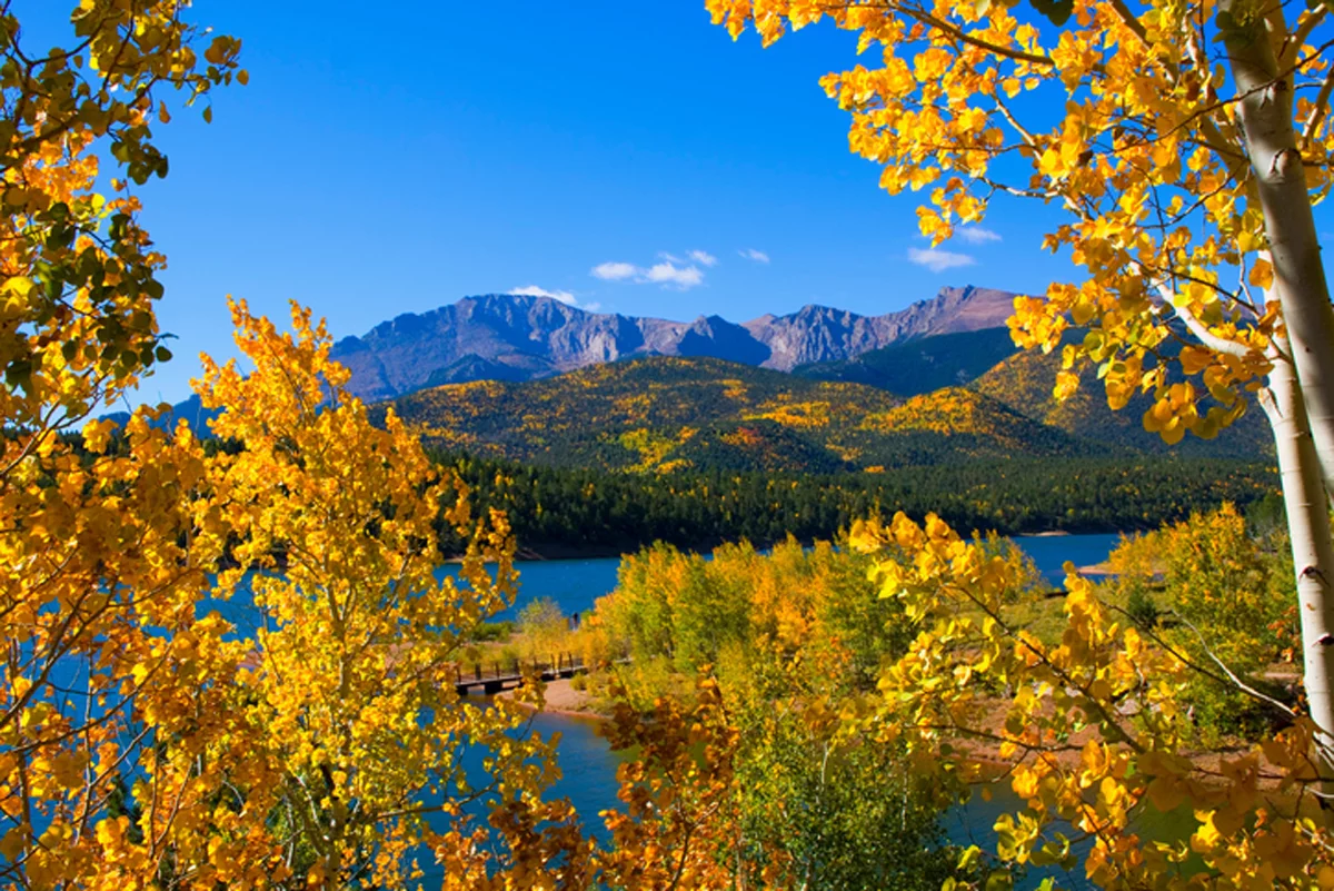
Hike, cycle or ride a horse: Rampart Reservoir, Rainbow Gulch Trail
Hike: The Crags
Hike: Mueller State Park – Cheesman Ranch Loop

Drive: Gold Belt Tour
Drive: Cripple Creek
Northwestern Colorado (Steamboat Springs and Craig):
Stroll: Yampa River Core Trail
Mountain bike: Emerald Mountain
Hike: The Devil’s Causeway in the Flat Tops Wilderness Area
Bike, hike and picnic: Elkhead Reservoir State Park near Craig
Drive: Rabbit Ears Pass